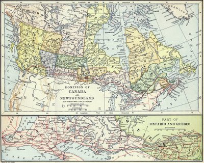
It’s that time again! Both to celebrate our rich national heritage in 60-second increments (fake version) (real version) and to look at maps again. A few weeks ago in the Soho area of NYC, we ran across an antique map dealer. A little haggling later, I ended up with the following piece of wall candy.
You can click on the map for the full version. It’s a little bit mysterious: I had never heard of many of the regions shown. The map shows:
- Athabasca (1882-1905)
- Assiniboia (1882-1905)
- Keewatin (1876-1912)
- Saskatchewan and Manitoba being broader east-west than north-south
- the non-existence of the Yukon territory (created in 1898)
- Northeast Territory
Many of these listed areas were districts, or administrative subsets, of the Northwest Territories. However, Franklin and Mackenzie districts, both created in 1895, are not shown.
The map has one fishy part. It seems like there was never really any part of Canada officially called the Northeast Territory. Says The New International Encyclopædia (1916),
[after talking about events in 1895]… At this time … that part of Keewatin which was north of Ontario, and the territory northwest of Quebec, were named the Northeast Territories. But the latter designation was discontinued, and eventually both the Northwest and the Northeast Territories, together with the district of Keewatin, became known as the Northwest Territories.
and Municipal Government in the North-West Territories (1904),
Some years ago Ungava appeared on the map as the North-East Territory, but by what authority is not known.
But is it reasonable that there was some confusion; after the Keewatin Act (1876), the Northwest Territories would have had two non-contiguous parts with a giant gap in the middle, and one might well wonder why they were all so “west”.
On the map, the part depicted as “the Northeast Territories” indeed resembles the District of Ungava’s 1895-1898 boundaries, but described more simply, consists of the area east of the Hudson Bay. There is another hint in the excellent Wikipedia article Territorial evolution of Canada, which would seem to place the map between May 7, 1886 and August 12, 1889 (when Manitoba lost a border dispute with Ontario in the Canada (Ontario Boundary) Act).
When I took out the map to scan it, the back side included a table entitled
UNITED STATES COMMERCIAL STATISTICS
From the Report of the Secretary of the Treasury for the Year ending June 30, 1890.
I guess the mapmaker was a little out of date, or not closely following Parliament, or had their map printed a bit late. The map is signed W. H. Holmes at the bottom, which Wikipedia seems to suggest is William Henry Holmes. Who, incidentally, published a work that sounds amazing based on the title alone: “Random Records of a Lifetime, 1846-1931: Cullings, largely personal, from the scrap heap of three score years and ten, devoted to science, literature and art“. Thanks Mr. Holmes, for this random record of history on Canada day!
Post-script. Here are two more bonus maps:
- map from an 1888 textbook that seems to be identical in fonts and the placement of many letters, although it has updated borders and the “Northeast Territory” label is absent
- map of Toronto from 1894

Map of Toronto from 1797: